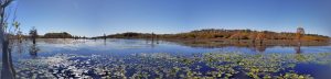
|
|
|
Assessing the Potential of Creating Management-Quality Invasive Plant Maps of Lake Gaston with Data Generated by Volunteer ScoutsRESEARCH SUMMARY:Lake Gaston is colonized by several aquatic invasive species including hydrilla, which covers over 15% of the lake. Hydrilla forms dense mats that restrict swimming, boating, and suppress property values. Hydrilla displaces natural vegetation, reduces habitat quality for fish, provides breeding habitat for mosquitoes, impede s commercial navigation, reduces drainage and increases flooding, and blocks intakes for hydroelectric turbines and potable water. Few management tools are available for aquatic weeds. Proper selection and integration of management techniques requires accurate vegetation surveys. In Lake Gaston, private contractors are hired to generate vegetation maps each fall, at a cost of $30,000 to $40,000. The accuracy of these maps could be increased or the cost of production decreased by utilizing trained volunteers. As numerous Lake Gaston residents have expressed an interest in actively contributing to lake environmental efforts, this project was developed to evaluate the feasibility of creating management-quality vegetation maps using these volunteers. Objectives:The objectives of this research were to:
Methods:Volunteers were trained in the identification of seven aquatic plant species, (including hydrilla) and the use of the handheld GPS units. Fourteen volunteers worked alone or in groups of two to scout weeds during the months of October and November. Scouts sampled in areas of their own choosing, and used their own boats (both motor boats and kayaks). Volunteers recorded GPS coordinates using a computer program written by Patrick Dempsey (Band XI International). Volunteers measured water clarity and depth, as well as presence or absence of hydrilla and 6 other aquatic weeds. Conclusions:
Mapshttp://www.cropsci.ncsu.edu/aquaticweeds/lgmaps/ Future Efforts:Current efforts will be extended through 2008 with additional volunteers expected. Volunteers will be surveyed to determine time investment of each volunteer. The data collected from this research may serve as a complement (to ground-truth) data collected by the independent contractors. Future efforts could include assigning part of the lake to contractors in an effort to reduce scouting costs. It is also expected that the location of hydrilla growth could be tracked using the GPS data and comparing growth from year to year to determine long-term spread or control. |
|
| HOME | ACADEMICS | EXTENSION | RESEARCH | PERSONNEL | FACILITIES | SEARCH | CONTACT US |
|
|
| POB 7620 Williams Hall NCSU, Raleigh, North Carolina, 27695 |
|
(919)515-2647 MAIN OFFICE (919)515-7959 FAX contact_cropsci@ncsu.edu |